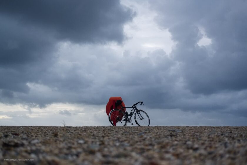
Rides bikes, paddles sea kayaks, takes pictures. Life on the road & my home in Cornwall.
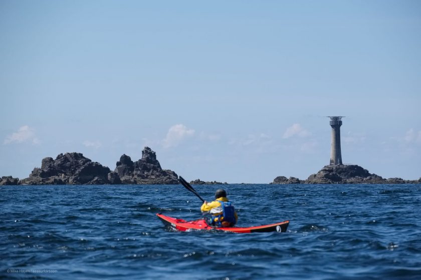
Sea Kayak Saltash to Sennen
Posted on
An impromptu sea kayak journey along the coast of Cornwall from Saltash to Sennen Cove. 190km over four and a half days made for a super mini-adventure close to home.
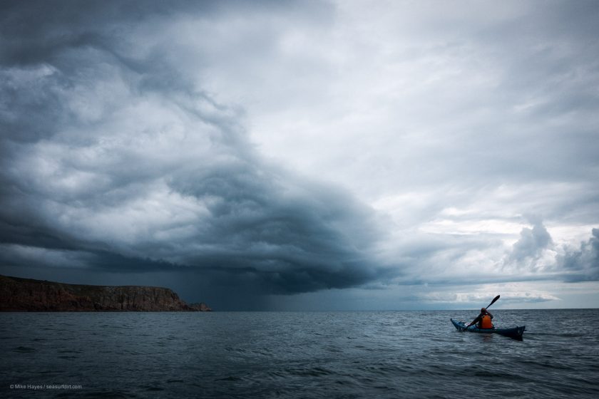
May was mostly cold, wet and windy, or if it wasn’t then it certainly felt as if it was. A weather window suitable for a quick escape did however present itself last week so camping gear was thrown at kayaks for a journey along the south coast of Cornwall from Saltash to Sennen Cove.
Despite knowing this coast well I had never joined it all up into a single kayak journey, and while it is also said that familiarity breeds contempt, being familiar with it in no way diminished the journey. Quite the opposite occurred as a deep satisfaction was enjoyed from the passing landmarks – Rame Head, Gribbin Head, Chapel Point, The Dodman, St Anthony’s Lighthouse, Lizard Point, Rinsey, Tater Du Lighthouse, Treen, and Lands End – counting down the kilometres to arriving back in what feels like my home turf amongst the granite of the far west.
We very quickly fell into the easy routine of getting up around 6-6.30 and being on the water for 8am. It was good to be back in that groove with no news, no internet, no nonsense.
We covered the 190-ish km in about 4 and half days, and it also proved to be the perfect escape from the general madness of a sunny bank holiday weekend ashore, just dipping a toe in from time to time to replenish water supplies or enjoy a quick icecream. What follows is something of a quick photo diary of the journey.
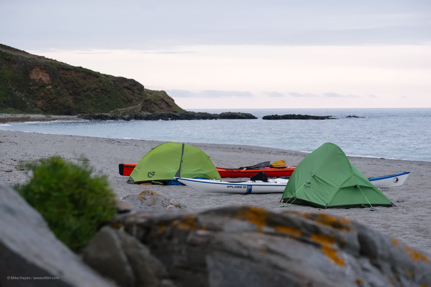
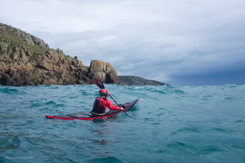
Putting in under Brunel’s famous rail bridge across the Tamar at Saltash. We managed to get afloat for 3pm Wednesday on the flood tide.It’s about 12km to reach the ocean proper at Penlee Point, making use of eddies where possible to avoid the full flow of the flooding tide. It’s not pretty but for someone used to the rugged coast of the west it was kind of interesting paddling past all of Plymouth’s riverside infrastructure, including the naval dockyards. I thought perhaps best not to be seen photographing those.Late afternoon heading past Penlee Point towards Rame Head. In Cornish Penn Legh means ‘stone-slab headland’, it marks the entrance to Plymouth Sound.Around 7.30pm, after around 27km, we parked ourselves on a quiet stretch of sand for the night.Last bird…The rise of the full “blood moon” over Rame Head was breathtaking, but I wasn’t carrying a suitable lens for effectively photographing such a thing so you’ll have to take my word for it. It was a beautiful evening with last light past 10pm.We very quickly fell into the easy routine of getting up around 6-6.30 and being on the water for 8am. It was lovely to be back in that groove with no news, no internet, no nonsense.Mirror calm at 8am below the cliffs near Tregantle. There is a Ministry of Defence firing range here so do check the times of operation if planning on paddling this way: https://www.gov.uk/government/publications/tregantle-firing-noticeConditions stayed completely calm for the morning, heading west towards Looe.Lantic Bay, near Fowey, for lunch. Between Looe and Lantic Bay the coastline is, happily, almost devoid of development, and with little wind it was a stretch of paddling accompanied by loud and abundant birdsong from the cliffs. Rather lovely.Early evening at Chapel Point, near Gorran Haven, after some 48km of paddling for the day. Friends and I used to fish off here as kids, it will always feel like a special stretch of coast.Unfortunately one of our number had to pull out near the end of day two, hence just two tents. It was another deliciously quiet, albeit rainy, night.This Minke whale had swum closely by us earlier in the day. It showed up again after dinner, swimming laps while feeding in the bay not 50m from my tent. I failed miserably to capture a decent shot of its lunges out of the water, too unpredictable, but an absolute treat to watch.Also residents… and always watching, always waiting whenever there is food around..A rainy morning below the brooding cliffs of Dodman Point (or Deadman Point). The Dodman is, at 114m, the highest headland on the south coast of Cornwall. A number of craft have met their end here, the most well known perhaps being the Darlwyne with the loss of 31 lives: https://www.bbc.co.uk/news/uk-england-cornwall-36906604Spider crabs moult in the springtime, completely shedding their exoskeleton in order to grow. Beaches along the way were absolutely littered with the evidence. I thought about taking the time to collect and assemble a complete exoskeleton, but then decided I couldn’t be bothered in favour of simply kicking back with a mug of tea.That mug of tea on the way.Another lovely camp…..backed by a profusion of wildflowers with a soundtrack of birdsong.This collapsed cave is near Cadgwith.Heading around Lizard Point, the most southerly spot in Britain; it very much felt like an important milestone in the journey. Apologies for the soft photo, conditions were quite bouncy at times with both a decent swell and tide running – I had water on the lens.Heading past Gunwalloe towards Loe Bar. This stretch of sand requires walking a little bit in order to reach it, so it’s never busy. It’s also a very dangerous stretch for swimming so not appealing in that respect. We made a brief stop into Porthleven a for mid-afternoon icecream; a very civilised way to travel…Discretely tucked away the evening before the final stretch down to Lands End. Passing by all the time it is easy to take St Michael’s Mount for granted, but it is actually quite a special thing. As always we pitched up late, were gone before most folk had finished breakfast and left nary a trace.Another satisfying milestone. The lighthouse at Tater Du feels very much like a gatekeeper to the rugged granite of the far west. Situated just west of Lamorna Cove it is Cornwall’s newest lighthouse – first lit in 1965 – and constructed in response to the loss nearby, with 11 lives, of a small Spanish coaster, the Juan Ferrer, on 23 October 1963.The headland at Treen, another milestone… beyond here are the turquoise seas of Pednvounder and Porthcurno.This is in fact Porth Chapel a little further beyond Porthcurno but the ‘look’ is the same. Instagram in particular has not been kind to these places as they are overwhelmed with visitors – shitty, selfish parking, littering, fly-camping and so on badly impacting the lives of those that live and work in the area, and making it impossible for emergency services to respond to incidents.Big smiley face. We both looked like old-school mimes, faces whitened by a heavy layer of sunblock. There are no photos beyond this point as the wind rapidly freshened to a force 6, gusting 7 easterly with a steep wind swell on top of a heavy 2m ground swell from the south west. It was fantastic fun and we made it round Lands End in record time, surfing the swells and tide at an average of 11kts (20km/hr).. the lively conditions demanded full attention so my camera remained firmly stowed. Turning northeast for the final couple of km into Sennen Cove turned into a bit of a slog – battling the strong headwind while avoiding the swells exploding on the many submerged reefs. Terrific fun and a fitting end to the journey.
Like this:
LikeLoading...
10 thoughts on “Sea Kayak Saltash to Sennen”
Great to have a journey to write about – great work.
Hi mate, you might not post much these day’s but when you do, you always bring a bit of joy into my day.
Looks like a fantastic trip, I only kayak infrequently in my sons old 12’6 and enjoy it when I do, I will have to do a little more this coming summer. A question on your mates paddle, the one who had to cut the trip short, what is the thinking behind the design? Easier on the body or more efficient ?
Thanks again for taking the time to share your journeys, and your positive thoughts with us.
hey Stephen, thanks for taking the time to write, and for the kind words, much appreciated.
With regard to the paddle, it’s a Greenland paddle; a design first developed by the Inuit paddlers of Greenland, centuries (if not millenia) ago. The dimensions are generally based on the body dimensions of the paddler (there’s some insight and a guide for making one here, a nice project: http://www.seakayak.ws/kayak/kayak.nsf/0/52FF1FE66E3A5E5685256C820015E8A6). It’s a very efficient paddle, and especially for long days it places less stress on muscles and joints than a euro-style blade. The chap in the pics with one has a shoulder injury so the Greenland paddle works particularly well for him. I made one from carbon a while ago, the posts are buried on this blog, i should tidy them up and make into a single article really.


Great to have a journey to write about – great work.
ha yes, it’s been a while! Also.. cheers!
Looks an amazing adventure Mike. Bet that paddle around Lands End got the adrenalin going!!
hey Andy, ha yes it was exciting… in a good way!
Wonderful!
cheers Mike!
Memories,
Not boating. same trip, cycling, at that time age 17years 1943, now 98 years living in Canada ,since April 1953.
Unfortunately, I am the last one alive in this age group of friends in England and Canada’
Thank you, just going back so many years with the memoirs made my day..
hey George, thanks for writing, and sharing your story, that’s lovely. How time passes though….! I’m glad you enjoyed the read.
Hi mate, you might not post much these day’s but when you do, you always bring a bit of joy into my day.
Looks like a fantastic trip, I only kayak infrequently in my sons old 12’6 and enjoy it when I do, I will have to do a little more this coming summer. A question on your mates paddle, the one who had to cut the trip short, what is the thinking behind the design? Easier on the body or more efficient ?
Thanks again for taking the time to share your journeys, and your positive thoughts with us.
Stephen.
hey Stephen, thanks for taking the time to write, and for the kind words, much appreciated.
With regard to the paddle, it’s a Greenland paddle; a design first developed by the Inuit paddlers of Greenland, centuries (if not millenia) ago. The dimensions are generally based on the body dimensions of the paddler (there’s some insight and a guide for making one here, a nice project: http://www.seakayak.ws/kayak/kayak.nsf/0/52FF1FE66E3A5E5685256C820015E8A6). It’s a very efficient paddle, and especially for long days it places less stress on muscles and joints than a euro-style blade. The chap in the pics with one has a shoulder injury so the Greenland paddle works particularly well for him. I made one from carbon a while ago, the posts are buried on this blog, i should tidy them up and make into a single article really.